Nippersink Lake
The Central Hub of the Chain
Lake Size
Average Depth
Maximum Depth
Body Type
Nippersink Lake
Map & Quick Facts
-
CountyLake & McHenry County
-
Connection TypeFox River Connected
-
Nearby CommunitiesFox Lake, Spring Grove, Pistakee Highlands
-
Speed LimitFull power – no wake near bridges and designated zones
-
Swimming AllowedYes
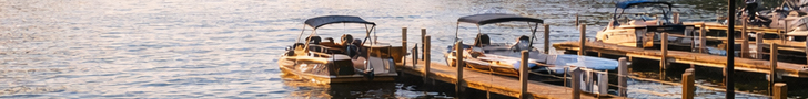
Boating & Lake Access
Boat Launches
Marinas
Access Points
Activities & Rentals
Activities Available
Equipment Rentals Available
Nippersink Lake
Fishing Information
Fishing Quality
Best Fishing Seasons
Fishing License
Fishing Tips
Fishing Regulations
History & Features
Historical Information
Nippersink Lake is one of three natural water bodies in the Chain, formed by Wisconsin glacier melting thousands of years ago.
The Cut: The historic hand-dug channel was created by the Dunnill family and Converse Marble between Pistakee and Nippersink Lakes, causing strong current and fresher water along the east shore. It is now deep, wide, and heavily traveled.
Railroad History: The railroad crossed the Chain at the narrowest point between Pistakee and Nippersink Lakes (current Route 12 location). A station built at Nippersink Point in 1901 became the center of the Fox Lake community.
Notable Features
Point Comfort Peninsula β Distinctive landmass pointing north creating a barrier between Nippersink and Fox Lakes. Features condo living with direct Chain O’Lakes access.
Beer Can Bridge (Route 12 Bridges) β Two bridges spanning the lake: state highway and parallel train trestle. Historic swivel turret bridge (now frozen) with high side and low side openings.
The Cut β Historic hand-dug channel connecting to Pistakee Lake, now a major boat thoroughfare.
Lake Front Park Beach β Public beach area off Nippersink Blvd for swimming and recreation.
El Puerto Mexican Restaurant β Major waterfront dining destination with boat and waverunner parking.
Central Hub β Strategic location connecting Fox, Grass, and Pistakee Lakes with 23 miles of shoreline.


